
Home > Trip > Dispatches > Trip Dispatches > Trip Dispatch #18
Trip Dispatch #18, Sunday, June 5. Embarcadero Creek Road to La Garita Cow camp: Maps versus GPS
We woke to see the sunrise; the sun was an orange fireball in the fire haze. We traveled alongside the road and talked for a long time with a man who gave us some specifics about the area. We also talked for a while with another motorist, a fellow named Chad, who said he was a farrier. He gave Pete his card and said to give him a call when we needed to have the horses shod. This could be fortuitous because farriers are busy people at this end of the world. It would not be inconceivable that we’d have to wait two, three weeks for a visit. This was our first day of traveling in hilly terrain since the first few days after leaving Andrea’s. After riding for a while, we met up with two motorcyclists. |
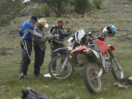 Pete conferring with mapping motorcyclists |
| Dennis and Drew (with the requisite technology on hand) were doing mapping for the Forest Service. It was (nicely) pointed out to us that our USFS maps information is 14 years old. This explains why we can’t find certain trails. Still, I like our going the paper route as opposed to our using a GPS since it makes this trip seem like more of an adventure. Dennis and Drew mentioned that there are two trails we might take, and said that the La Garita Trail is the easier of the two. Even so, this was no cakewalk. The trail was rocky, steep, and log-strewn. I’d never ridden anything like this before, so my stomach was in my throat on both the up and downhill stretches. |
|