Home > Dispatches > Daily Dispatches 2020 >Daily Dispatch #196
July 16, 2020: Thompson Pass and the Great Walkabout
This turned out to be the toughest day of my trip, even tougher than the first day, when I pushed my bicycle up the Old Nenana Highway hills. I didn’t have a watch handy, and my cell phone was out of juice, so I had no idea what time it was when I got up. It was overcast, and I knew that I would not be able to sleep, so I got up. I couldn’t sleep thinking about my upcoming bicycle repairs, the wobble being my main concern. The first thing I did when I got out of my tent was check the pressure in the rear tire. I breathed a sigh of relief in discovering that it was still firm when I squeezed on it. After eating and organizing my gear, I took the piece of thin wire I found in the road and fastened it to the cotter pin, and then |
|
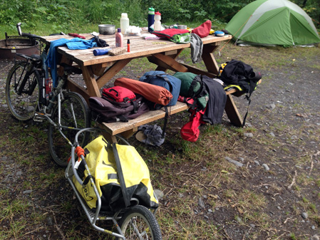
fastened the cotter pin to the B.O.B. stay. I was pleased to discover this worked. There was nothing I could do about the bent axel. I had originally planned on riding to the base of Thompson Pass and going over it tomorrow. I finally decided to go over it, and for three reasons. The first was that it was a mere 35 miles to the top. The second was that I thought that if I hoofed it, I’d meet up with Fran and Sarah, my Fairbanks friends who were planning to come to the area to hike. And my third was that, according to my Milepost pages, there were no places to camp between here and the top. So my day’s end destination was the Blueberry Lake campground. It was a beautiful early morning ride; I could see the mountains in the distance, which were enshrouded by low lying clouds. I saw a lot of jackrabbits, hopping back and forth across the road. For the first ten miles or so, the foliage was green and lush. After that, there were meandering rivers. Early afternoon, and I came across brush cutter devastation – all I could think was that rabbit habitat was being destroyed. The vegetation became increasingly more sparse as I began climbing. The road grade then steepened considerably, I then did the math. I had eight miles left to go. I could, with seven miles left, see the Cal Worthington glacier – it was like a wall of ice. It kept disappearing and then reappearing, as I wound my way upward. My sense, that the glacier was indeed cold, was intensified by the cold headwinds that accompanied the sight of it. Oh yeah, I was now pushing a very wobbly bicycle. I came to the turnoff area, parked my bicycle against a large rock, and sought shelter from the wind in a three-sided kiosk. There I ate my lunch. I considered riding the half mile to the glacier and checking out the interpretive information, but I by now felt a great need to get to my destination. As I ate my trail mix, another touring bicyclist passed me. I yelled out to him that I was bicycling and either he did not hear me or chose to ignore me. It sure would have been fun to have company going the last few miles uphill. I felt more energetic after eating, but not energetic enough to ride. The winds, they were so strong. And my bicycle, so wobbly. So I rationalized my walking by reminding myself that I was seeing more than if I was riding. There were some small downhill stretches, maybe two or three. These were a nice break. The terrain became more alpine like. The mountains, I was in them. I stopped a few times and took in the clouds, very wispy and fast moving. And I thanked dog it was not raining. Cars and trucks, long lines of them, had been passing me periodically. I hadn’t had any traffic to contend with until I got to the base of Thompson Pass. I kept going, and I cheered inwardly every time I passed a mile marker. There were snow markers too, but no sign that said Thompson Pass. So I had no idea that I had reached the top when I reached the top. I got back on my bicycle and started coasting downhill. Of course, I felt euphoric. Who wouldn’t feel this way? I was clued in to the fact that there was construction work on the far side of the pass when I began passing an outrageously long line of cars and trucks. I wondered if this meant that I was going to get a ride. I hoped it was after the turnoff to the Blueberry Lake Campground, in which case I’d go by vehicle in the a.m. I simultaneously saw the flag person, bright orange and yellow against the gray foggy background, and felt my rear tire go ssszzzz. I stopped, got off my bicycle, and felt it. Dang, I had a second flat. My sense of denial wasn’t as strong as the first time around because I could see a blue sign that read Blueberry Lake Campground. This, of course, meant that I was nearly done for the day, and in being done, I wouldn’t have to deal with this, the second flat tire. The flag person gave me permission to go ahead, and so I half ran, half walked my bicycle to the turn. During this time she held the traffic up. The road to the campground was paved, easy to walk. I found the campground and the sites. The first thing I saw was a picnic shelter, and under it, a picnic table. I noticed that the non-sheltered sites were reserved – this, I thought, must be the day use area. I snagged it, sat down, and breathed a sigh of relief. What remained was 25 downhill miles to Valdez. If I had to, I could carry my bicycle and B.O.B. the final distance. |
|