Home > Trip > Dispatches > Daily Dispatches 2013 > Daily Dispatch #168
September 4, 2013: Mackay’s Mine Hill Tour-on Horseback
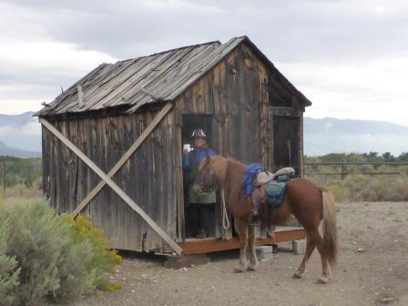
Today we decided to do something a bit different and settled on doing a tour of the Mackay Mine Hill area. Pete spotted the information about the tour on a kiosk outside the rodeo ground. I was dubious because it appeared to be total guy stuff. But Pete’s suggesting that we do this by horseback (of course) appealed to me. Any excuse for a ride. Last night we picked up a map at the local Chevron station. It noted that the tour is sponsored by the South Custer County Historical Society and the White Knob Historical Preservation Committee in conjunction with the City of Mackay, Custer Country, the U.S. Forest Service, and the Bureau of Land Management. It’s a self-guided tour of mining locations. According to map information, the mine hill is the most significant part of the Alder Creek Mining District. Ore was first discovered in 1878, meaningful production began in 1884, and ore was mined into the 1980s. Almost a million tons of ore have been removed over the years, yielding about 42,000 ounces of gold, 2,000,000 ounces of silver, 62,000,00 tons of copper, 15,000,000 pounds of lead, and 5,000,000 pounds of zinc. Geological sampling still occurs, and mining could resume at any time. The tour consists of three distinct routes, red, green, and blue routes. We decided to mix and match, so as to cover ten or so miles, a comfortable distance for the dogs and horses. We were most interested in checking out the railroad trestle, so our cobbled together route included this. |
|
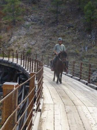
| So this morning we set off, driving the trailer about a half mile outside of town to the vicinity of where the tour began. We took a lunch, rain gear, and the veterinary kit. The first stop, which was close, was the smelter site and hard rock mining exhibit. It was (we discovered) the home base of the Shay mining railroad and location of the ore hauling aerial tramway and tramway unloading terminal. It featured the restored Shay engine house, a blacksmith and machine shop and an eight hole outhouse. I went to check out the latter with Raudi in tow – she badly wanted to step inside, but I erred on the side of caution and kept her outside. We next rode up to the aerial tramway and towers. We learned that the tramway operated on gravity power; the loaded ore buckets going down pulled the empty, or often loaded with equipment ore buckets back up. Most of the 26 tramway towers have been dismantled or fallen down, but enough remain to get a sense of how this portion of the operation worked. It was after checking out site #2 that we wisely decided to continue the tour on foot. It was hot, and the horses’ winter coats are coming in. For this reason they were less than enthused about walking up road. It was actually a good hike – along the way to the top we checked out the Cossack Tunnel and Compression building, the White Knob Townsite, The North Bullion Tunnel, the Aerial Tramway Headhouse, and the Alberta Level and Tunnel Site. Finally, after lunch, we came to the Shay Railroad Bed Overlook, which took us along a wooded ridge. Here we were in the shade, so we climbed back on the horses. This was the most enjoyable portion of the trek, with the Shay Railroad Trestle coming in a close second. According to interpretive information, the trestle was built by the White Knob Mining Company about 1901 as a part of the electric railroad system used to shuttle ore and supplies between the mines and smelter. It spans 105 feet, and is 25 feet tall. It was initially required to support the load of the electric motor engines and ore cars, but in 1905 the heavier, more powerful coal fired 140 ton Shay trains were put into service. The entire rail system gave way to the gravity powered aerial tramway in 1918. The trestle was a popular tourist crossing until it was condemned in 1998. It was rebuilt in 2002. The newer trestle resembles the old, except for the fact that there are now side rails for safety and traffic restrictions to vehicles over 50 inches in width. The interpretive information also indicates that this is a great photo site. Well, we took advantage of this, and took innumerable photos of Raudi and Signy crossing the span. Neither were bothered by the plonking of the planking or the height. Raudi did figure out that we were pretty high up, and three quarters of the way across, her eyes did get a bit bulgy. Otherwise, it was business as usual. We walked a good portion of the way down because it was very steep and there was a lot of loose gravel. But we did stop and check out the Empire Ore Bin Location – a pile of rubble and a stone wall are all are remains of the bins which were built about 1905. Finally, the road became less gradual. It was then that we resumed riding, ending our trek back at the trailer. The dogs immediately sought shade under the trailer, and the horses dozed as we untacked them. A good day’s ride – something a bit different for us all. |
|